Jun 18 2012
Monitoring of Hydraulic Gradient in Agricultural Land-Use Using Grid Wireless Sensor Networks
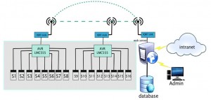
 This study discusses about monitoring system of hydraulic gradient as a parameter which observed to detect the occurrence of landslide on agricultural land-use in the sub district of Kalibawang, Kulon Progo, Yogyakarta, Indonesia. Hydraulic gradient was observed by using low-cost sensor, gypsum block, combined with AVR LMC555, single chip microcontroller, to read soil moisture content. Sensor node positioned as grid distribution to provide equitable and accurate measurement during soil deformation. Wireless sensor networks technology, IQ Radio Frequency( IQRF) and web databases introduced as an alternative technology which can applied to simplify data transmission and information distribution. Hydraulic gradient was observed with the visual observation of soil moisture content as a head approximation in each sensor node.
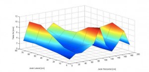
  Distribution of soil moisture content in grid system displayed in three dimensional graph to represent soil condition during rainfall induced within a certain time. Verification test of the proposed monitoring system was carried out in the laboratory stage to study about the behavior of the hydraulic gradient and performance of monitoring system. Soil layer was prepared using soil test box (0.74 m x 1.85 m x 0.25 m) filled with the equal soil in research site. Rainfall generator was adapted to supply the intensity of rainfall up to 115.5 mm/day. Further development, low-cost sensor and concept of hydraulic gradient as a hydraulic parameter of landslide occurrence can be use for early warning system with combination with other commercial sensors to enhance the accuracy of the system.